


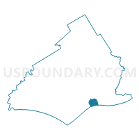
EDDYSTONE PCT SOUTHERN, Delaware County, Pennsylvania
About
Outline

Summary
| Unique Area Identifier | 659184 |
| Name | EDDYSTONE PCT SOUTHERN |
| County | Delaware County |
| State | Pennsylvania |
| Area (square miles) | 1.41 |
| Land Area (square miles) | 0.88 |
| Water Area (square miles) | 0.53 |
| % of Land Area | 62.60 |
| % of Water Area | 37.40 |
| Latitude of the Internal Point | 39.85484850 |
| Longtitude of the Internal Point | -75.33710720 |
Maps

Graphs
Select a template below for downloading or customizing gragh for EDDYSTONE PCT SOUTHERN, Delaware County, Pennsylvania


Neighbors
Neighoring Voting District (by Name) Neighboring Voting District on the Map
- CHESTER WD 03, Delaware County, PA
- CHESTER WD 05 PCT 02, Delaware County, PA
- CHESTER WD 05 PCT 03, Delaware County, PA
- EDDYSTONE PCT NORTHERN, Delaware County, PA
- Greenwich township voting district 1, Gloucester County, NJ
- RIDLEY TWP WD 01 PCT 01, Delaware County, PA
- RIDLEY TWP WD 01 PCT 02, Delaware County, PA
Top 10 Neighboring County Subdivision (by Population) Neighboring County Subdivision on the Map
- Chester city, Delaware County, PA (33,972)
- Ridley township, Delaware County, PA (30,768)
- Greenwich township, Gloucester County, NJ (4,899)
- Eddystone borough, Delaware County, PA (2,410)
Top 10 Neighboring Place (by Population) Neighboring Place on the Map
Top 10 Neighboring Elementary School District (by Population) Neighboring Elementary School District on the Map
Top 10 Neighboring Unified School District (by Population) Neighboring Unified School District on the Map
Top 10 Neighboring State Legislative District Lower Chamber (by Population) Neighboring State Legislative District Lower Chamber on the Map
- General Assembly District 3, NJ (235,440)
- State House District 162, PA (58,896)
- State House District 159, PA (55,766)
Top 10 Neighboring State Legislative District Upper Chamber (by Population) Neighboring State Legislative District Upper Chamber on the Map
- State Senate District 9, PA (277,401)
- State Senate District 26, PA (251,041)
- State Senate District 3, NJ (235,440)
Top 10 Neighboring 111th Congressional District (by Population) Neighboring 111th Congressional District on the Map
- Congressional District 7, PA (673,623)
- Congressional District 1, NJ (669,169)
- Congressional District 1, PA (655,146)
Top 10 Neighboring Census Tract (by Population) Neighboring Census Tract on the Map
- Census Tract 4107, Delaware County, PA (5,279)
- Census Tract 5005, Gloucester County, NJ (4,899)
- Census Tract 4041.02, Delaware County, PA (4,833)
- Census Tract 4041.03, Delaware County, PA (3,322)
- Census Tract 4043, Delaware County, PA (2,410)
- Census Tract 4048, Delaware County, PA (2,136)